16 inch or above Navigation Systems for regular Joe
I had passion for boats as far back as I can remember, perhaps the same time I got interested in recreational fishing. Fast forward a few decades and I'm in a position to purchase a boat and last summer (2019) I had the opportunity to get some hands on experience with the latest in Marine GPS Navigation Systems for boats (yachts if you wish). Here is a list of things bothering me:
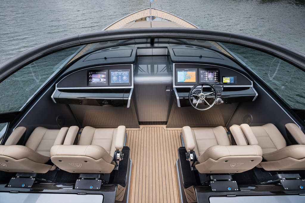
- 4 999 USD for a 16 inch low-res monitor with a low-end computer
- Poor UX design, mixing touch gestures with buttons
- Separation displays from the rest of the system
- Theft prevention off by default or cost extra
- Autopilot is extra
First of all, touch displays make a lot of sense on your phone, where you can click, pinch zoom, two finger drag or what not. When it's foul you just rub it against any cloth and it's clean again. A 16 inch display under direct sunlight means every single fingerprint is visible even at 1200 nits (a regular iPad is around 400-490 nits and iPad Pro ~600 nits). Here is a video to show you what these numbers mean in sunlight:
The touch interactions are not rock solid and a lot of stuff is buried inside menus and settings in such a way that touch doesn't really make a lot of sense. Remember a lot of the companies do not have a single designer of any kind employed and mostly work with external agencies - so forget that any UX designer had a say.
The lack of UX design in these products are fairly obvious, especially for a software engineer that is used to have a dedicated UX designer working in every team. But that should keep costs down, right? As a lot of other companies most people working there don't use the product and I this goes for engineers as well.
If you ever opened a navigation systems there are two things going on, either the enclosure is air tight or it has air vents but no protection for humidity or water. So nothing has been done about the internal heat and I can tell you even a small 9 inch IPS at 1200 nits heats up quite a lot and it's all black. And if something has been done it's all wrong and if condensation is a real problem where you live, then you are out of luck.

A Dashboard should be dark so you don't get reflections, but light so it doesn't heat up. Difficult compromised, but it doesn't look like anyone has even tried?
Why not make a new line of Navigation Systems?
GPS is a fairly old standard, all GPS receivers use NMEA (NMEA 0183 or NMEA 2000 aka NMEA2K) which is basically a serial ASCII based communication (it doesn't get simpler than that in tech). You can get a GPS receiver as low as 20USD and for a few hundred dollars you get a marine branded one:

An iPhone X at 800 nits is unfortunately not enough when used in direct sunlight, so I'm looking into sourcing IPS monitors at 1500 nits or above in size of 16-24 inches. The idea is that you can upgrade your display according to your wallet without changing anything else. Here is one possibility: https://www.prtronic.at/Durability_Sunlight/2118_E/
Navigation apps for iPhone
Navionics Boating App (iPhone)
OpenSeaMap (iPhone)
SeaPilot (iPhone)
AvNav (Android)
Navigation software for Windows and Mac OSX
OpenCPN (Github)
OpenSkipper (Github)
OpenPlotter (Github)
OpenNauticalChart (Github)
OpenBoatProject
DIY by Ole W Saastad
Bareboat
qtVlm
OpenSeaMap (Github)
Wikimapia (API)
Alternative standalone GPS for use with third party monitors
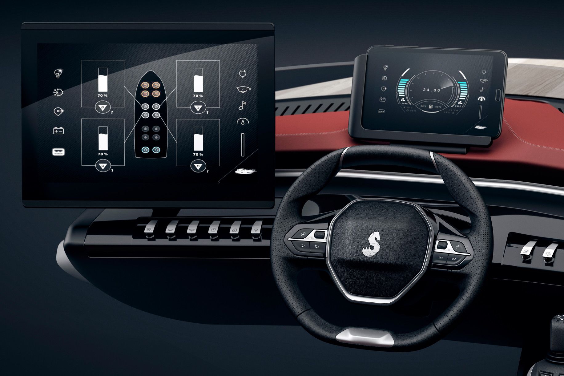
Features
IPS monitor 16-32 inch >1 000 nits
WXGA (1366 × 768) or Full HD (1920 x 1080)
No touch display
Trackpad near your throttle arm
Improved UX design
Quick access split screen overview map and a depth chart
Alerts when steering towards shallow areas
Automatic brightness adjustment when you look away
Strong theft protection (just like an iPhone)
GPS and GSM jammer detection
VHF is an upgrade
VHF used for alarms (in case of GPS and GSM jammers)
Autopilot is a cheap hardware upgrade
Multi-user support
Crowd source live depth charts, marina information, warnings, theft alerts
OpenCPN software (or similar) (Github)
Subscription based software and charts
iPhone and Android integration for on-board internet
Second screen - iPad, iPhone, Android, PC, Mac
AIS integration
Weather information and wind charts(GRAB file) , tide information
Advanced routing to destination with speed limits
Google Maps integration
Chart merge, using multiple vector charts Bluchart g3 or Navionics
Declutter overview maps (less depth information - intuitive)
Radar as hardware upgrade
Engine information
Built-in 600W Fishfinder (Sonar)
Airmar Chirp Transducer (B765LH)
Sonar power upgrade (to 1kW or 2kW)
App Store for 3rd party apps
Music service (Spotify, MP3, FLAC)
FLIR infrared camera
Berthing cameras front and back
IPX6/IPX8 rating (more than 1m depth)
Aqua Compact Pro (Win10, Intel i3, 120GB SSD, 8GB RAM) - optional
Budget
| 16 inch IPS monitor | $1 000 retail |
| GPS receiver | $200 retail |
| Airmar Sonar Transducer | $1000 retail |
| Navionics Platinum+ Large Charts | $300 retail |
| Raspberry Pi or PocketBeagle | $60 retail |
| Total | $2160 retail |
Different chart providers:
https://www.raymarine.com/marine-charts/

List of OEM components:
13,3 inch 1500 nits
Argonaut 15 inch 100o nits
21,5 inch 1500 nits, Full HD
MOITESSIER HAT 2 (AIS, GNSS)
RTL-SDR USB dongle (AIS)
Random Facts:
Swedish HAM radio magazine
Marine VHF Frequency range 156 MHz to 174 MHz
AIS Channel A 161.975 MHz (87B)
AIS Channel B 162.025 MHz (88B)
AIS Class B (2W)
AIS Class A (12.5W)
RTL-SDR AIS Receiver Tutorial
https://www.openstreetmap.org/
Polar Diagrams for Sailing
Celestial Navigation
Augmented Reality Navigation
Inmarsat EGC Messages with RTL-SDR
Ok, I went down the SDR rabbit hole, so there will soon be an SDR post. I thing I did in high-school was morse code encoding and decoding. Basically you type and it plays the morse code or vice versa. The person who gave me my first soldering iron was an avid HAM radio enthusiast with no college degree, he thought himself electronics and build his own radios. Which by the way was very illegal in communist Poland in the 80's.
RTL-SDR and clones using the E4000 chip operate at 64MHz to 1700MHz and here are some things you can find in that range:
- DVB‐T (174‐240MHz, 470‐858MHz)
- CMMB Terrestrial (470‐858MHz)
- D‐TMB (174‐240MHz, 1452‐1492MHz)
- ISDB‐T (470 – 862MHz)
- DVB‐H (470 – 858MHz, 1672‐1678MHz)
- T‐DMB (174 – 240MHz, 1452 – 1492MHz)
- DAB/DAB+ (174 – 240MHz, 1452 – 1492MHz)
- GPS L1 band (1575MHz) – (with additional LNA)
- FM radio (64 – 108MHz)
Apparently the E4000 chip is better below 700Mhz compared to R820T and I'm interested in Marine VFH (156-174MHz) and AIS is within that frequency. E4000 had a range of 51.850…>2080MHz, with a gap of 1105…1268MHz. The R820 had a range of 24…1766MHz without a gap. I would be interested in Weather RTTY but that is below the frequency for both chips. Fortunately there is a HF up-converter you can get here for another 49USD. Maybe I should have got one as well?
E4000 vs R820T comparison
HF Weather Fax
German Weather Service RTTY (CW aka Morse Code) Frequencies
More on Weather RTTY
And yet some more on RTTY
CWSkimmer (CW aka Morse Code to text software)
Nooelec LaNA (29 USD - yes I bought one)
Nooelec NESDR SMArTee XTR Bundle (48 USD - yes I bought that too)
The Hobbyist's Guide to the RTL-SDR (Book - ordered)